The data here is written by BAWA IELTS FEROZEPUR considering plagiarism policy.
The given two
maps focus on the town named Lynnfield in 1936 and then in 2007. Overall, a
number of changes had made during the given span.
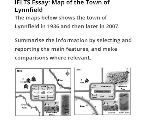
According to the provided data, in 1936, three trees were there in the North-West direction, and in 2007, a single tree was there, and two trees were uprooted completely. Moreover, the river flowing in the North-East had been removed and swapped with the residential area after 71 years. Further, the farmland in the South-East had been demolished, and in 2007, people were facilitated with the golf course. Adjacent to farmlands in the South direction, there were government offices in 1936; however, in 2007, a museum had been built. Besides, the cycle path in the South-West had been replaced by a road after nearly seven decades.
Additionally, in the exact centre of this town, a rectangular area was there having a few facilities. To start with, in the just upward direction of the centre, the sweet shop was there, and butchers were located in the East North-East direction in 1936. In 2007, the supermarket had swapped sweet shops as well as butchers. The location of the library remained unchanged during both years. This library was situated in the South South-East.
In both years, the bank remained unchanged in the slight down of the centre. Flower shop in the South South-West had changed to travel agent works. The post office also remained unchanged in the West North-West direction. Finally, on the space of wasteland in this rectangular area, in 2007, a shopping centre had been constructed.
